Why use nautical miles and knots in sailing?
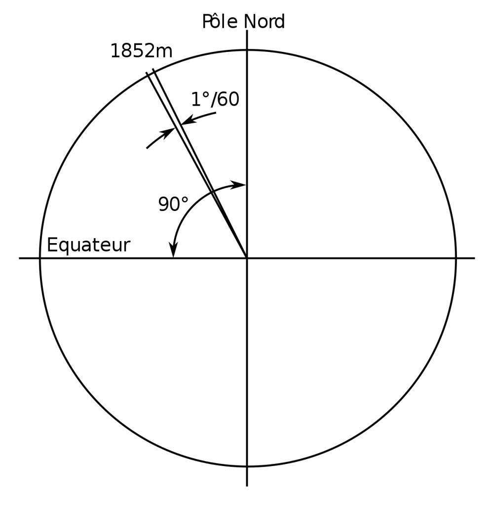
We use nautical miles and knots in sailing because a nautical mile is based on the circumference of the earth. One nautical mile equals one minute of latitude or 1/60 of a degree. It takes one hour to sail one nautical mile at a speed of one knot. We use nautical miles and knots for navigating and plotting charts.
In order to get a better grasp on this concept and to hone into the “why”, we need to unpack this a little and look at the individual components. The collaboration between these components still underpins why we use nautical miles and knots in sailing in today’s digital world.
- What are nautical miles?
- Why divide the globe up in 360°, minutes and seconds?
- What is latitude (parallels)?
- What is longitude (meridians)?
- Why use knots?
1. What is a nautical mile?
A nautical mile is used in navigation by the air, marine, and space industries. It equals 1852 meters. A nautical mile can be described as one minute (1/60 of one degree) of latitude along any longitude line; more on latitude and longitude below.
Technically, a nautical mile is an average the brains trust of the day agreed on because of the irregularity of the globe; it is a little flatter at the poles. In any case, for all intents and purposes, we can say that a nautical mile is 1852 m or one minute of latitude.
Nautical miles can be abbreviated in several ways depending on what industry you are from. In sailing terms, we are happy with just “nm”.
2. So why 360°, minutes and seconds?
360 is a nice number that was adopted since there were eyes looking at the sky. It represents the 360 days in a year which was as accurate then as can be expected.
As a side note, the moon goes through one full cycle of phases in about 30 days. 360 days divided by 30 days is 12. Thus a year was split into 12 months.
But we digress… Our current decimal system is relatively new. Instead of a “base 10” system, the Babylonians (influenced by the Egyptians) gave us a base 60 or sexagesimal system because 60 was seen as a superior number as it has a large number of factors. Ie, you can divide it by a lot of other numbers…
So now we have 360 degrees. Each degree could be subdivided into 60 minutes, and those 60 minutes further subdivided into 60 seconds etc…
This method, in essence, is what we are still using today with the only exception that on most charts subdivisions of seconds are in decimal. For example, 20°46′23.43454″
Note the use of the notation:
- Degree = °
- Minute = ′
- Second = ″
However, for the purposes of plotting points on your chart, you would usually use degrees and minutes and convert any seconds to a decimal. For example,
Convert 40° 19′ 30″ N
30″ / 60 = 0.5′
Latitude: 42° 25.5′ N
Making a grid…
We all have heard about a “grid reference”. To know where we are on a map or a chart we need a grid system that can pinpoint our location or the location of things so we know the relationship between where we are and where we need to go. Having criss-cross lines on a map or chart will do that job nicely as long as we can understand what these lines are called and understand the relative distance between them.
Obviously, our globe is round(ish) and not a flat map so we need to adjust for this. How we do this is another story for another time…
So let’s put some names to these grid lines now…
3. What is meant by latitude?
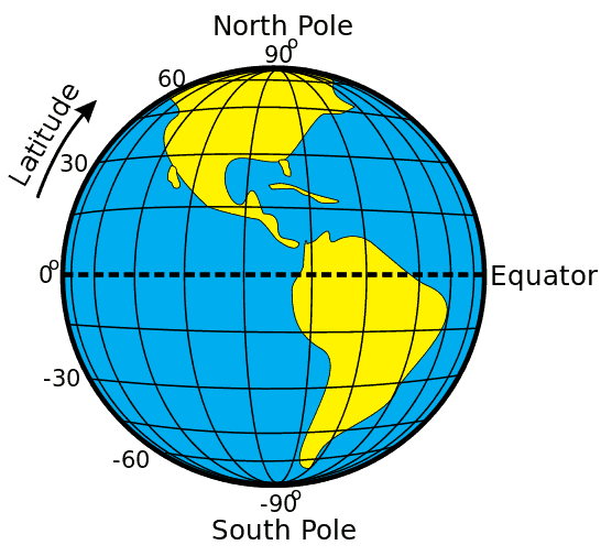
Think of latitudes as “lines” that run east to west across the globe but tell you where you are on a north-south line called a longitude.
We also refer to latitude lines as parallels. In total there are 180 degrees of latitude.
0° represents the equator whereas 90° represents the North Pole and -90° represents the South Pole.
We can also look at the 5 major parallels which are from north to south: Arctic Circle, Tropic of Cancer, Equator, Tropic of Capricorn, and the Antarctic Circle.
Latitude has a bit of “ladder” in it (with a bit of imagination) so that may remind you that we measure latitude on a vertical.
In a grid reference, we usually state latitude first. For example:
34° 54.5′ S 143° 35.8′ E
4. What is meant by longitude?
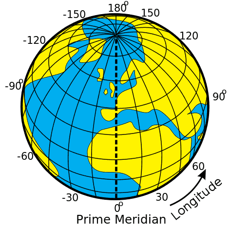
Conversely, think of longitude as “lines” that run north to south across the globe but tell you where you are on an east to west line called a latitude. Lines of longitude are also called meridians.
There are 360 degrees of longitude. The centre of which is known as the Prime Meridian which passing through the Royal Observatory, Greenwich, England. It divided our globe into the Eastern Hemisphere (-180 degrees of longitude west) and the Western Hemisphere (180 degrees of longitude east).
Longitude is normally stated last. For example.
34° 54.5′ S 143° 35.8′ E
5. Why do we use knots?
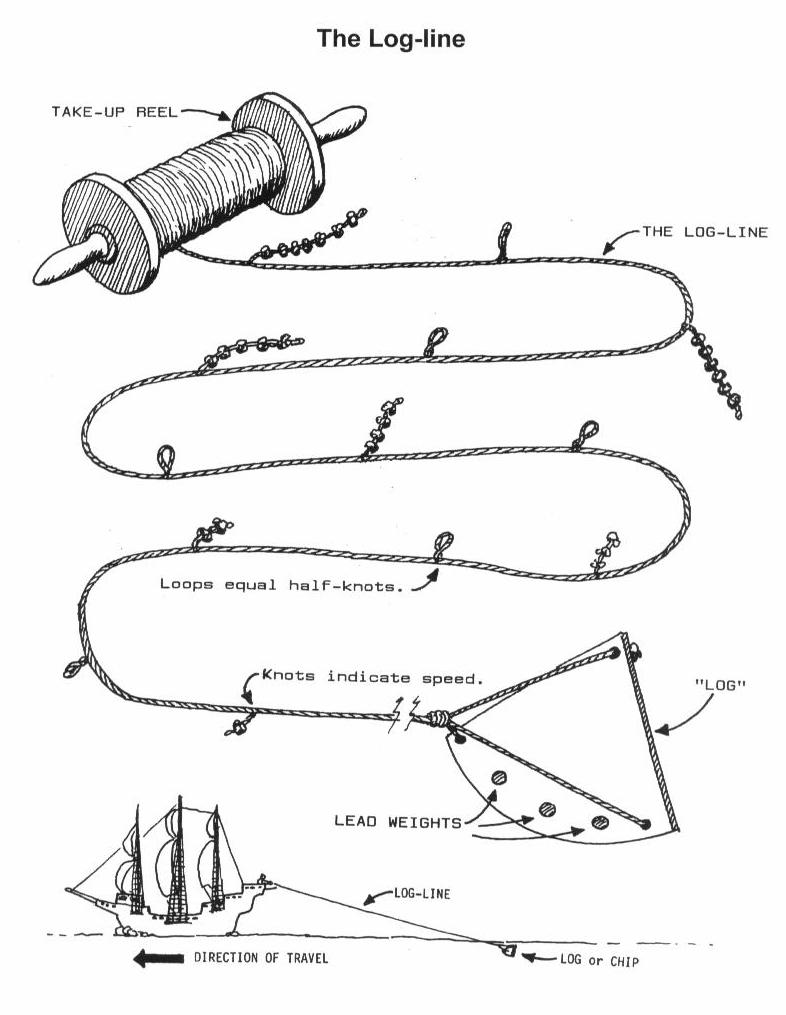
A knot is an old maritime measure of speed. If you cover one nautical mile in one hour you will be travelling at a speed of one knot.
The term knot dates from the 1600s, when mariners measured the speed of their ship by deploying a tool called the “common log.” This tool was a coil of line with uniformly spaced knots, attached to a piece of triangle-shaped wood. The piece of wood was lowered into the water behind the ship and allowed to float away behind it. The line was allowed to extend from the coil as the distance between it and the ship was timed. When the specified time had passed, the line was pulled in and the number of knots on the line between the ship and the log was counted. The speed of the ship was determined by the number of knots counted.
So there… Clear as mud. Hopefully, you know a little more about why we still use what at first-hand looks like an old and antiquated system. Next time you plot a course you may think back and thank the old guard for inventing such a great system…
If you want to get a better understanding, I recommend the movie Longitude with Stephen Fry as Sir Kenelm Digby and directed by Charles Sturridge. A great historical movie that explains the challenge of determining longitude within the British Navy.
If the article was helpful then don’t be afraid to share it on social media. If you find something that you consider inaccurate then let us know. We love to hear from you so leave a comment below… Find other articles here…